High-Performance Computing Center Stuttgart
Developing tools that help communities to prepare for and manage the emerging risks that climate change holds is the focus of Feldmann’s research. “We aim to statistically assess the frequency, intensity, and spatial distribution of extreme weather events under climate change,” he explains. To do so, he is investigating how a powerful, high-resolution simulation approach called convection-permitting modeling (CPM) could improve scientists’ ability to assess and predict such risks more precisely at the local level. Using the Hawk supercomputer at the High-Performance Computing Center Stuttgart (HLRS), he and his colleagues have been investigating whether CPM could offer benefits over other modeling approaches. Their work has also begun generating information that could help guide future adaptation.
Although widely used regional climate models (RCM) can provide useful insights about climate and extreme events, they cannot accurately represent the characteristics of localized heavy rainstorms. The typical mesh size used in RCM simulations is 12 to 25 km, which does not provide sufficient resolution to capture important features that affect the impacts of extreme weather. For example, RCM cannot resolve localized details when simulating factors like temperature, precipitation, topography, or soil conditions, all of which can mean particular risks for specific communities.
Convection-permitting modeling could potentially represent the risk of extreme events more realistically. In CPM, atmospheric conditions are simulated at a scale of less than 4 km. This means that in addition to capturing a much more refined model of the atmosphere and its relation to the landscape, CPM provides scientists sufficient resolution to study convection, the atmospheric process in which warm, moist air rises to form rain clouds. Using this higher-resolution approach, they can simulate the evolution of convective processes without the parameterization necessary in coarser models.
Large supercomputers have made it feasible to use CPM to simulate the effects of extreme events in specific areas on climate timescales. The downside, however, is that CPM is much more computationally demanding that RCM. Currently, it is a huge effort to use this approach on global or long-term scales because of the time it would take. This means that as they look to the future, atmospheric scientists would like to better understand when and how CPM could be used most effectively.
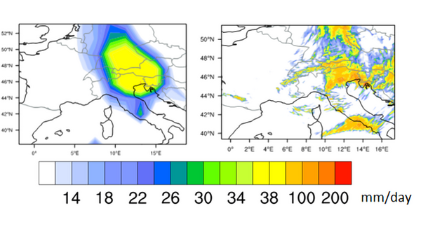
In a recent paper published in the journal Weather and Climate Dynamics, Dr. Alberto Caldas-Alvarez, a former KIT postdoc who coauthored the publication with Feldmann, compares results of convection-permitting modeling to those of regional climate simulations. The team’s goal was to determine whether CPM could, in fact, simulate local properties of extreme rainfall events better than regional models.
The research was conducted as part of the German Federal Ministry for Education and Research (BMBF)-funded ClimXtreme project, in which Feldmann coordinates the module “Physics and Processes.” The project is focused on identifying atmospheric patterns associated with extreme weather events.
By analyzing historical weather data gathered in the European Alps between 2000 and 2015, Caldas-Alvarez first identified past extreme precipitation events. He then used a statistical approach called principal component analysis to determine the specific atmospheric conditions that were typically associated with them. In the next step, he analyzed regional climate and convection-permitting simulations of the same period to see how well their representation of extreme storms corresponded to actual historical measurements.
The team found that convection-permitting modeling was, indeed, better than regional climate modeling in identifying extreme precipitation events. At the same time, they also detected relevant differences in how the two modeling approaches simulate the processes responsible. The findings present open questions that future research will explore to better understand the strengths and limitations of each approach.
Despite these questions, CPM’s higher accuracy in representing extreme precipitation events suggests that it could help to develop regional climate adaptation strategies. “Convection-permitting modeling provides a much more realistic distribution than traditional regional climate modeling when compared to observations,” Feldmann says. In the second phase of the ClimXtreme project, he and his team aim to further increase understanding of extreme events such as heavy precipitation, heat waves, and wind storms.
As a member of another BMBF-funded project called RegIKlim (Regional Information for Climate Action), Feldmann has been working to develop climate information for practical use that could help local communities across Germany develop better planning and risk management strategies. He co-coordinates the subproject NUKLEUS (Nutzbare Lokale Klimainformationen für Deutschland), whose goal is to generate, evaluate, and make available CPM climate simulations to support decision making. In addition, he is a principal investigator in a RegIKlim companion project called ISAP (Integrative city-regional adaptation strategies for a growing polycentric region: Region Stuttgart), which is using high-resolution climate information to support climate change adaptation in the area surrounding Baden-Württemberg’s state capital.
For a publication in the journal Natural Hazards and Earth Systems Sciences, Feldmann and the ISAP/NUKLEUS team generated an ensemble of regional climate simulations of future heat waves in southern Germany. By combining different regional convection-permitting climate simulations run on HLRS’s Hawk supercomputer, they once again investigated the benefits of the CPM approach. Their findings provide a host of insights into what the future might hold under climate change.
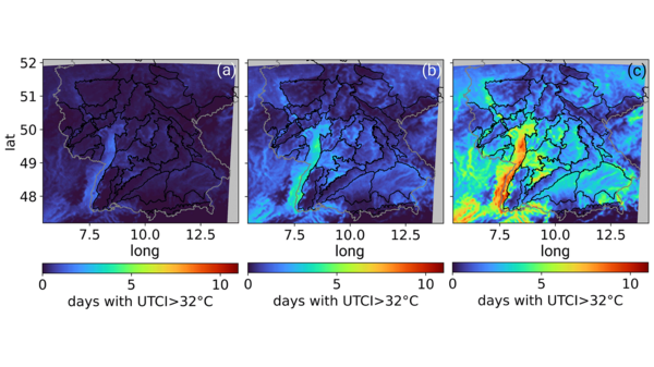
The ISAP/NUKLEUS team found, for example, that the probability of heat waves in Germany will increase, particularly in the late summer. Their severity is also likely to become significantly worse in a warming climate. The resulting heat stress will depend on features in the landscape, with the most severe stresses likely in the Rhine River Valley. Convection-permitting modeling provided the regional specificity needed for this nuanced climate change projection.
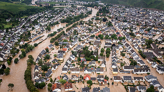
In another study, Feldmann and colleagues investigated the historical context of the Ahr flood, comparing it to observational data of past heavy precipitation events. They found that although historical events with comparable severity occurred in 1804 and 1910, they weren’t recorded in the observational network used to determine current flood risks, which only dates back approximately 70 years. One lesson of their study is that risk modeling should begin to incorporate hydrological conditions and changes in land use that have occurred over the years. In the future, they suggest, it will be important to combine such information with better models of changing climate conditions to be able to make better predictions of risk.
“We need climate data to derive statistics of where and under which circumstances heavy precipitation events are more likely to occur, just as for other atmospheric extremes such as heat waves. This is valuable information for decision makers and industries such as urban planning or construction,” Dr. Caldas-Alvarez observes. “Investing in high-performance computing and high-resolution modeling can help reduce the large uncertainty associated with such weather extremes. This aids in making decisions that could better protect human lives, infrastructure, and investments.”
These days, Caldas-Alvarez is no longer at KIT but works in Innovation and Development at EDP, a multinational renewable energy company. In this role, he uses climate science in an applied way, developing analytical tools to improve solar and wind yield predictions. “Being in a renewable energy company every day you experience how important it is to have access to accurate and highly-resolved predictions and simulations,” he reflects. “We need to get the best quality we are capable of, as sometimes biases smaller than 1 m/s make the difference between pursuing or dismissing wind projects.”
By continuing to study and refine convection-permitting modeling, Feldmann and his partners aim to improve the scientific tools needed to make better projections in the future.
— Christopher Williams
Caldas-Alvarez A, Feldmann H, Lucio-Eceiza E, Pinto JG. 2023. Convection-parameterized and convection-permitting modelling of heavy precipitation in decadal simulations of the greater Alpine region with COSMO-CLM. Weather Clim Dynam. 4: 543-564.
Hundhausen M, Feldmann H, Laube N, Pinto JG. 2023. Future heat extremes and impacts in a convection-permitting climate ensemble over Germany. Nat Hazards Earth Syst Sci. 23: 2873-2893.
Ludwig P, Ehmele F, Franca MJ, et al. 2023. A multi-disciplinary analysis of the exceptional flood event of July 2021 in central Europe – part 2: Historical context and relation to climate change. Nat Hazards Earth Syst Sci. 23: 1287-1311.
Funding for Hawk was provided by Baden-Württemberg Ministry for Science, Research, and the Arts and the German Federal Ministry of Education and Research through the Gauss Centre for Supercomputing (GCS).
A member of the Gauss Centre for Supercomputing, HLRS is one of three German national centers for high-performance computing.